Great Loop FAQs
Questions about the Great Loop Route
What Exactly Is the Great Loop?
What Waterways Comprise the Great Loop Route?
Because there are several points on the route where there are choices that may send you to different waterways, we recommend you examine our Public Interactive Map. However, the primary waterways on the basic route include:
- The Atlantic Intracoastal Waterway
- The Chesapeake Bay
- The C&D Canal
- The Atlantic Ocean from Cape May to New York Harbor (or sometimes inland waterways through part of New Jersey)
- The Hudson River
- The Erie Canal (or a popular route option on the "Triangle Loop")
- The Oswego Canal (or continue on the Erie Canal to Lake Erie)
- Lake Ontario
- The Trent-Severn Canal
- Georgian Bay
- Lake Michigan
- The Illinois River
- The Mississippi River
- The Ohio River
- The Tennessee River
- The Tenn-Tom Waterway
- Mobile Bay
- The Gulf Intracoastal Waterway
- The Okeechobee Waterway (or continue on the Gulf Intracoastal to the Keys)
How Many Miles Is the Great Loop?
How Long Does It Take to Do the Great Loop?
We’re seeing a trend towards people doing the Great Loop in segments, cruising for a few weeks or months, and then returning home to take care of business or other responsibilities, and returning to the boat for another segment when possible.
How Many States/Provinces/Countries Are Along the Great Loop?
The US. and Canada are usually part of the Great Loop, although one route option keeps you within the U.S. borders. Some Loopers do a side trip to the Bahamas as well.
Depending on route choices, you will go through at least 15 U.S. states and Canadian provinces, which may include:
- Florida
- Georgia
- South Carolina
- North Carolina
- Virginia
- Maryland
- Delaware
- New Jersey
- New York
- Vermont
- Quebec
- Ontario
- Michigan
- Wisconsin
- Illinois
- Missouri
- Kentucky
- Tennessee
- Mississippi
- Alabama
Where on the Loop Is the Starting Point?
I'm Ready to Start the Great Loop. When Should I Leave Based on My Starting Point of. . .
You can leave from anywhere on the Great Loop route but when you start is often dictated by where you start. There is a definite seasonality to the Great Loop as locks and facilities in its northern sections are closed in the winter. This is, in part, why the Great Loop traditionally was done in one year, following the warm weather around the Loop. That said, some Loopers choose to cruise smaller sections at a time and pay less attention to the seasonality described below. That works well too! Just be sure to read the information below to know what you may be dealing with if you are in a section of the Great Loop in the off-season.
AGLCA has divided the route into segments and each segment is outlined below with the appropriate starting point for each of those segments. For more detailed information on the segments, including sample itineraries, GPX files and overview videos, visit the Great Loop Segments area here on the website.
As you review the seasons below for each segment, keep in mind that most Loopers average about 50 miles per day and most Loopers cruise one of every three days on average. The sample itineraries mentioned above can help with your planning and timing.
Florida’s East Coast & The Keys-Florida has more boats than any other state, so it’s common for Loopers to purchase their boats in Florida and start the Loop from there. If you start from this segment, early spring is the time to do so because you want to be out of the area prior to hurricane season, which starts June 1st. Insurance policies typically require boaters to be out of hurricane-prone areas during hurricane season. All policies are different so be sure to check yours.
Georgia thru the Carolinas-As with Florida, it’s best to start this segment in the spring because these coastal states can also be impacted by hurricane season, particularly in late summer and early fall. Starting in the spring in this segment also keeps you on schedule for what lies ahead in the next segments. You should be wrapping up this segment in time to arrive in Norfolk, VA, where you’ll complete the Atlantic Intracoastal Waterway, for the AGLCA Spring Rendezvous in early May. At the Rendezvous, Loopers can attend route briefing sessions that tell them what to expect as they leave the AICW and make their way further north for the summer and then down the inland river system in the fall.
Chesapeake thru New Jersey-May in the Bay is the mantra to remember for starting in this segment and you want to pace yourself to arrive in the next segment when the New York canals open for the season.
New York thru Lake Ontario-This segment is best started in late spring/early summer, with the goal of being on the Erie Canal in June. The Erie Canal's operating schedule is announced each year by the New York State Canal Corporation and usually opens in mid-May so don’t plan to arrive there until late May. The area can still have chilly weather in early spring so the later you can start, the better.
Canada-Due to the cold winters which limits the boating season in Canada, the prime time to start the Loop here is in early summer. It allows you to enjoy the beautiful waters of the Trent Severn Waterway and Georgian Bay at their peak before heading into the United States.
Lakes Huron and Michigan-The lakes also see cold winters so mid-summer is the best starting time in this segment with the goal of leaving Chicago sometime in September after Labor Day. Typically, Loopers have left shortly after Labor Day but in recent years, they have been able to extend cruising around Chicago, leaving later in September. It’s recommended that you not leave any later than early October, though, as marinas begin to close for the winter season.
Inland Rivers-Starting on this segment coincides with the beginning of fall foliage season. In the northern portions of this segment, marinas begin to close for the winter season in the fall so it’s best to start early in the fall if you can. But as you go further south, you’ll head to warmer weather as you approach the Gulf in Mobile, AL. The goal is to reach Mobile Bay in November. Since Mobile is in a hurricane-prone area, though, you’ll need to check your insurance policy to see how far south you can go in this segment, and in what timeframe. Some policies allow you to enter the Gulf any time after November 1st even though hurricane season ends on November 30th.
Gulf Coast-It’s best to avoid hurricane season (June-Nov) altogether when starting from this segment so winter is the traditional season to cast off those dock lines from the Gulf Coast of Florida. Insurance policies may also dictate when you can be in these waters.
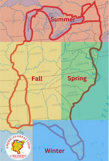
This map captures the Great Loop route by the seasons. Green represents spring, red represents summer, yellow represents fall and blue represents winter.
Why Is the Loop Usually Done Counter-Clockwise?
Why Do AGLCA Members Fly Burgees and What Do the Various Colors Mean?
The double swallow tail AGLCA burgee is the flag that binds America's Great Loop Cruisers' Association™ members. It's been called the welcome mat for Loopers and is proudly flown by our members whenever they are cruising. Members who fly an AGLCA Burgee receive instant recognition from the boating community and their fellow members.
The White Burgee is an indicator of AGLCA membership and can be flown by any of our members on any type of boat, even if it’s not your Loop boat.
The Gold Burgee is the "Gold Standard" and is reserved for members who have completed the Great Loop Cruise.
The Platinum Burgee has been specially designed to identify our most experienced Loopers, those who have accomplished multiple Loop completions!
And, our veteran Loopers who display the Gold and Platinum Burgees as their credential of completion(s) are accorded the respect that goes with being someone who has done extensive cruising on America's Waterways.
In addition to members, AGLCA sponsors can also be seen flying burgees.
The Red Burgee represents the highest level of AGLCA sponsorship and is flown by our Admiral sponsors.
The Green Burgee represents the second highest level of AGLCA sponsorship and those sponsors are known as Commanders.
The Blue Burgee represents sponsors at the Lieutenant and Lieutenant Plus sponsorship levels.
Wherever you see one of these colors flying you can be assured that these sponsors will do whatever they can to assist you with your Great Loop journey.
Questions about Great Loop-Capable Boats
What's the Best Boat for the Great Loop?
What Air Draft (Height) Restrictions Are There on the Great Loop Route?
The lowest unavoidable fixed bridge on the Great Loop is currently charted at 19.6’ and is located at mile 300.6 on the Illinois River. The boat you intend to use for the Loop must be able to clear that bridge. Some members with taller boats are able to get under 19.6’ by lowering antenna, radar arches, etc. About 8% of our members have sailboats. Most sailboats will need to unstep the mast to clear the bridges outside of Chicago and upstate New York.
Your choice of waterways through New York State and into Canada will also be dependent on your air draft. If you can clear a 15' bridge, you have the option to take the Erie Canal to its western terminus into Lake Erie. If you can clear a 17' bridge, you can do the "triangle loop" that takes you into Lake Champlain and through the St. Lawrence Seaway into Lake Ontario. (As an additional option on the triangle loop, if you can clear many eight foot bridges, you can take the historic, charming and free Lachine Canal through Montreal rather than the Seaway locks.) The final option is to take the Erie Canal to the Oswego canal to Lake Ontario. That route requires you to clear 21' bridges.
Your air draft will also dictate which route you take off Lake Michigan. To cruise the Chicago River through downtown, you must be able to clear 17' bridges. If you can't clear that, you will take the Cal-Sag Canal which is south of Chicago to the Illinois River.
What Is the Maximum Water Draft (Depth) for a Boat Doing the Great Loop?
What Is the Maximum Length for a Boat to Do the Great Loop?
What Is the Maximum Beam (Width) for a Great Loop Boat?
What Fuel Range Does My Boat Need to Have?